Search Earthquake Catalog
online search by time window, area, magnitude, and more
online search by time window, area, magnitude, and more
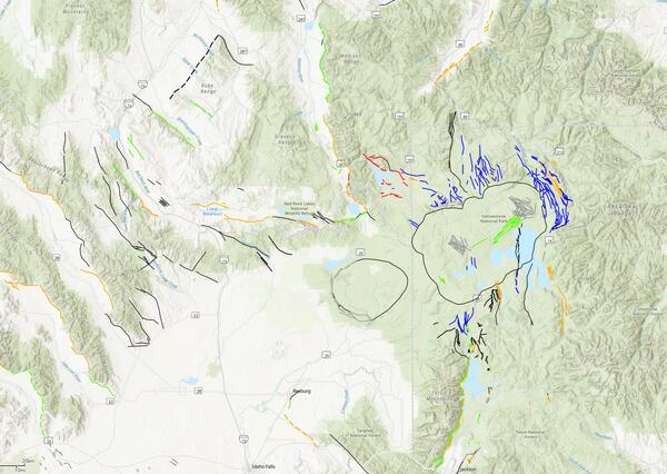
Machine Learning Mapping in the Sierra Nevada Mountains
A new study mapping the bedrock outcrops in California
A new study mapping the bedrock outcrops in California
Significant Earthquakes, Past 30 days
Significant Earthquakes, Past 30 days
5.7
3 km NW of San Vicente Pacaya, Guatemala
2025-07-08 21:41:31 (UTC)
Pager Alert Level: Yellow
MMI: VII (Very Strong Shaking)
10.0 km
6.3
212 km WSW of Riverton, New Zealand
2025-07-07 12:53:43 (UTC)
Pager Alert Level: Green
MMI: V (Moderate Shaking)
22.0 km
6.6
10.0 km
6.1
71 km ESE of Sarangani, Philippines
2025-06-27 23:07:10 (UTC)
Pager Alert Level: Green
MMI: V (Moderate Shaking)
101.6 km
3.6
5 km NW of Redding, CA
2025-06-27 10:57:11 (UTC)
Pager Alert Level: Gray (Null)
MMI: IV (Light Shaking)
20.6 km
5.7
77 km NNE of Punta Cana, Dominican Republic
2025-06-24 02:45:44 (UTC)
Pager Alert Level: Green
MMI: IV (Light Shaking)
68.0 km
5.6
37 km WSW of Callao, Peru
2025-06-15 16:35:29 (UTC)
Pager Alert Level: Yellow
MMI: VI (Strong Shaking)
40.0 km
5.7
3 km NW of San Vicente Pacaya, Guatemala
2025-07-08 21:41:31 (UTC)
Pager Alert Level: Yellow
MMI: VII (Very Strong Shaking)
10.0 km
6.3
212 km WSW of Riverton, New Zealand
2025-07-07 12:53:43 (UTC)
Pager Alert Level: Green
MMI: V (Moderate Shaking)
22.0 km
6.6
10.0 km
6.1
71 km ESE of Sarangani, Philippines
2025-06-27 23:07:10 (UTC)
Pager Alert Level: Green
MMI: V (Moderate Shaking)
101.6 km
3.6
5 km NW of Redding, CA
2025-06-27 10:57:11 (UTC)
Pager Alert Level: Gray (Null)
MMI: IV (Light Shaking)
20.6 km
5.7
77 km NNE of Punta Cana, Dominican Republic
2025-06-24 02:45:44 (UTC)
Pager Alert Level: Green
MMI: IV (Light Shaking)
68.0 km
5.6
37 km WSW of Callao, Peru
2025-06-15 16:35:29 (UTC)
Pager Alert Level: Yellow
MMI: VI (Strong Shaking)
40.0 km
Earthquake Hazards Program
The USGS monitors and reports on earthquakes, assesses earthquake impacts and hazards, and conducts targeted research on the causes and effects of earthquakes. We undertake these activities as part of the larger National Earthquake Hazards Reduction Program (NEHRP), a four-agency partnership established by Congress.
Latest Earthquakes
Latest Earthquakes

Latest earthquakes map and list (past 24 hours, M2.5+) from the ANSS (Advanced National Seismic System).
Search Earthquake Catalog
Search Earthquake Catalog

Find an earthquake or a list of earthquakes by time window, magnitude, area, and more, and choose the output format - map and list, CVS, and others.
News
USGS Announces Recipients of Recent Earthquake Research Grants and Cooperative Agreements
USGS Announces Recipients of Recent Earthquake Research Grants and Cooperative Agreements
M7.7 Mandalay, Burma (Myanmar) Earthquake
M7.7 Mandalay, Burma (Myanmar) Earthquake
USGS Seeks Earthquake Hazards Research Proposals
USGS Seeks Earthquake Hazards Research Proposals
Publications
Evidence for fluid pressurization of fault zones and persistent sensitivity to injection rate beneath the Raton Basin Evidence for fluid pressurization of fault zones and persistent sensitivity to injection rate beneath the Raton Basin
Subsurface wastewater injection has increased the seismicity rate within the Raton Basin over more than two decades, with the basin-wide injection rate peaked between 2009-2015. To understand the evolution of injection-induced earthquakes, we systematically analyzed 2016-2024 broadband recordings with a machine-learning-based phase picker and constructed a catalog with 95,993 earthquakes...
Estimating earthquake source depth using teleseismic broadband waveform modeling at the USGS National Earthquake Information Center Estimating earthquake source depth using teleseismic broadband waveform modeling at the USGS National Earthquake Information Center
The U.S. Geologic Survey National Earthquake Information Center (NEIC) monitors global seismicity, producing a catalog of earthquake source parameters in near-real-time to provide information that can help mitigate the societal impact of earthquakes. The NEIC commonly relies on teleseismic observations to constrain earthquake source parameters (e.g., location, depth, magnitude, and...
High-pass corner frequency selection and review tool for use in ground-motion processing High-pass corner frequency selection and review tool for use in ground-motion processing
Raw seismological waveform data contain noise from the instrument’s surroundings and the instrument itself that can dominate recordings at low and high frequencies. To use these data in ground‐motion modeling, the effects of noise on the signals must be reduced and the signals’ usable frequency range identified. We present automated procedures to efficiently reduce low‐frequency noise...
Science

Engineering and Risk
The well-known statement "Earthquakes don't kill people, buildings do" highlights the need to make our communities more earthquake resilient. The impact of earthquakes on public safety and the national economy can be reduced through improvement of the built environment to resist earthquake effects such as ground shaking. Extending natural hazards science to risk involves (1) conducting research to...

2025 Puerto Rico and U.S. Virgin Islands Long-term National Seismic Hazard Model
We anticipate the final 2025 PRVI NSHM to be available by December 21st 2025.
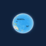
Public kickoff webinar: 2026 National Seismic Hazard Models for Guam & Northern Mariana Islands and American Samoa
Monday, February 24, 2025 2:00-4:00 pm MST A Virtual Meeting


 Earthquake")